Development and study of the Khibiny. Khibiny Mountains: general information, geographical location, photo Famous explorer of the subsoil of the Khibiny Mountains
The first names of mountains and rivers Khibiny massif gave by the academician Alexander Evgenievich Fersman. It was he who immortalized the name of the Finnish explorer Wilhelm Ramsay, naming the pass between Poachvumchorr and Takhtarvumchorr, Ramzai Pass, in his honor. Ramsay, a participant in Finnish expeditions, studied the Khibiny and the entire Kola Peninsula from late XIX century. The name Ramsay Pass appeared in 1920, and in 1997 a memorial plaque was installed on the top, reminiscent of the scientist’s merits in the development of the Khibiny.
Ramsay was not the discoverer of the Khibiny Mountains, but is considered their pioneer. The first memories of the massif were found on a map of the Russian Academy of Sciences, dated 1745. At that time, the Khibiny were designated as unknown mountains located south of Lake Imandra. The lake was marked on maps back in 1611, which confirms the travel of people along the Kola Peninsula already in those years.
If the Russians got to Imandra, then they could not help but notice the snow-covered Lopar tundra. Nevertheless, the official discoverers mountain peaks steel mining engineer Nikolai Shirokshin and academician Alexander Middendorf. Scientists visited the Khibiny in 1834 and 1840; these years are considered the time of the discovery of the Khibiny mountain range.
Ramsay's predecessors were also Russian and French travelers Nikolai Kudryavtsev and Charles Rabaud. However, Alexander Fersman singled out Wilhelm Ramsay most of all, considering his works to be classics of scientific coverage and the basis for further study of the Khibiny. Wilhelm Ramsay was the first to begin geological, petrographic and mineralogical research in the region. One of the minerals found in the Khibiny - ramzaite - is named in his honor.
Merits of Wilhelm Ramsay in the study of the Khibiny Mountains
Wilhelm Ramsay took his first steps in studying the Khibiny in 1887, when he was part of a Finnish expedition sent to hinterland Lapland. The geologist was not the formal leader of the company of scientists, but subsequently the trip was certainly associated with his name. This hike began the long-term work of the Finnish naturalist to study the geological features of the Lopar tundra. They continued for 40 years until the death of Wilhelm Ramsay.
During a campaign in 1887, Wilhelm Ramsay and his colleagues crossed the Kola Peninsula from the Kola River to Cape Svyatoy Nos, passing Kildin Island, the Voronya River, Lake Lovozero and the Ponoy River. By allowing deviations north and south from the intended route, scientists were able to create more full map terrain, examining the “white spots” of the central part of the peninsula. Then the Lovozero and Khibiny mountains were discovered, which no one knew about before.
Khibinsky mountain range revealed to Wilhelm Ramsay near Umbozero, when he was climbing to the peaks of the Lovozero tundra or Luyavrurt. But it was not possible to stop and spend a long time in those places. Only in 1891 and 1982, a group of scientists led by Wilhelm Ramsay spent two field seasons in the mountains, studying in detail the territory, topography and soil composition. The Finnish geologist was helped by his faithful companions - petrography specialist Viktor Gakman, geodesist and part-time astronomer Alfred Petrelius and flora researcher Oswald Chilman. Each of them left their mark on the history of the Khibiny, giving their names to mountains and rivers.
In honor of Alfred Petrelius, Alexander Fersman named three natural object: river, mountain and pass. It was Alfred Petrelius who compiled the Khibiny relief map. Thanks to him, the Kola tributaries to the Imandra and Umbozero rivers were determined.
Victor Gakman, together with Wilhelm Ramsay, collected a collection of minerals and rocks. After completing the expedition, he processed the materials obtained at the University of Heidelberg in Germany. As a result, he revealed the presence of new minerals, hitherto unknown to science. It was in the mountains of the Khibiny massif that deposits of sphene, loparite, lovenite, eudialyte, murmanite and astrophyllite were first found. The river flowing in the middle of Mount Yukspor was named after Victor Gakman.
Alexander Fersman gave the name to Mount Chilman in memory of the Scandinavian botanist Oswald Chilman. The mountain is located in the western part of the massif, although the scientist was studying vegetation in the east of the peninsula. It was Oswald Chilman who discovered the Cayva Hill.
No official confirmation of the discovery of the main wealth of the Khibiny by Wilhelm Ramsay has been found. There is no mention of apatite ore in his works. Nevertheless, academician Alexander Fersman compiled his map of useful minerals, where he pointed out the ring structure of the mountains, using the maps of Wilhelm Ramsay as a basis. Such information is presented in the multi-volume publication “Geological Study of the USSR”. Without the results of the work of the Finnish scientist, the apatite deposits would have remained unknown for a long time. Fersman himself said that the task of his research was a complete survey of the Khibiny Mountains based on the study of the works of Wilhelm Ramsay.
During the time of Wilhelm Ramsay, apatite ore was of no value to industry and Agriculture. Low level of technological development and special geographical conditions did not allow us to really evaluate the benefits of apatite and use it in practice. Therefore, the interest of science in this mineral was purely theoretical.
The Finnish geologist paid tribute to his predecessors. He named the peaks of the Khibiny Mountains after Charles Rabaud, Alexander Middendorf and Nikolai Kudryavtsev.
Wilhelm Ramsay described the research of the Kola Peninsula in 18 published articles and monographs. All works were published on German. Not a single article was ever published in Russian.
Khibiny is mountain system, attracting researchers and nature lovers since ancient times. They are not as difficult to reach as other areas. You can get to the mountains by car. Or another option is to get to Murmansk by plane or train.
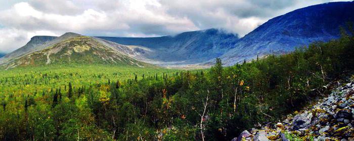
Location and terrain
The Khibiny Mountains are located between and Umbozero. They are an array consisting of plateau-like peaks. Highest point- 1201 m. This is Mount Yudychvumchorr, part of the Khibiny massif. The average height of the mountains is 1000 meters.
There are many traces of ancient glacial activity. Circuses and punishments talk about this. And also troughs - valleys plowed by a glacier, similar to troughs.
There are results of the activity of permafrost - kurums, the so-called stone rivers. And on the plateau there are entire stone seas.
Geological structure
The Khibiny Mountains are a crystalline structure - an intrusion. This is a solid geological body composed of rocks of igneous origin. There are only 8 such intrusions in the world. This is a horseshoe-shaped massif, mostly composed of rocks - nepheline syenites. In ancient times, there were huge volcanoes here, which cooled down and the magma crystallized. Therefore, about 800 different minerals were found here. Some of them are specific only to a given territory.
Names of modern settlements correspond to the minerals found here: Nepheline sands, Apatity, Titan. After the heavy glacial shell descended from these mountains, this territory experienced tectonic uplift. It occurred unevenly, as evidenced by the nature of the geological structures. They look like funnels, the edges of which are composed of older rocks than the center. For approximately 20 million years, the Khibiny Mountains rose 500 meters above the surrounding plains. Then there was a long break of 15 million years. Then the mountains began to grow again, this time their height doubled.
Climate
The Khibiny Mountains have climatic conditions that depend on geographic location. On the map of the North-West in the European part of Russia you can see that most of the peninsula is located beyond the Arctic Circle. Despite this fact, the climate here is much warmer than in other areas. local weather smoothed out by proximity Barents Sea, since the North Cape Warm Current enters this part of the ocean. Therefore, the climate here is quite mild, and severe frosts are relatively rare.

Due to the location of the Khibiny in the Arctic, twilight reigns here for six months. In winter, daylight hours are very short and last 2-3 hours. The polar night lasts about four months - a period when the sun does not rise above the horizon. And due to its proximity to the planet’s magnetic pole, a very impressive phenomenon can be observed - northern lights.
Summer lasts two and a half months. The highest positive temperatures are +20 in July. The average for the month is +13 degrees. The coldest period lasts during January. average temperature month -11 degrees. And the Khibiny Mountains have the most negative mark in winter -35 0 C. Photos of these places show that there are often fogs and high clouds here. This indicates the influence of cyclones on the territory. Precipitation falls mostly in the form of snow.
Flora
The vegetation cover consists of several zones. The zone of coniferous and mixed forests is located mainly at the foot of the mountains and in river valleys at low altitudes. This belt ends at an altitude of 470 meters and occupies a third of the massif. It is dominated by spruce and birch. In the forest you can find rowan, aspen and bird cherry.
Higher up begins the zone of subalpine birch forests. It stretches as a narrow strip between the belts of forest and tundra. Swimmingweed, geranium, and thistle grow here.
Next comes the mountain-tundra zone. It occupies about half of the entire area of the Khibiny Mountains. Below, shrubby vegetation is common. The berry season continues in early August. Blueberries, blueberries and cloudberries are ripening. At the beginning of autumn, the time for lingonberries comes. Above is the moss-lichen tundra. Green and sphagnum mosses predominate here. Lichens cover large boulders stone rivers. Many plants included in the Red Book grow here.
Toponymy of names
The Sami are considered the indigenous people in the Khibiny region. On the map of these mountains the names are entirely in the language of this people. However, their meanings are different. Since there are several dialects in the Kola Peninsula.
One of the versions of the origin of the name of the mountains is from the word “khiben” - a flat hill. The Sami conventionally divided the Khibiny mountains into two parts: Umbozero and Lavozero. The first in their language sounded like Umptek, the second - Luyavrurt.

The Sami first came up with the name of the river, and then the valley was named from it. And only then the ridges were designated. The first part of the word is a sign of an object (high, rocky). The second meant geographical feature(mountain, river, lake). For example, Lake Vudyavr. Wood - a hill covered with bushes. The root of yavr is lake. Thus, the Sami gave simple descriptions of objects. Among them is Vudyavr - a lake on a hill with bushes.
The Khibiny Mountains are a wonderful region that you just want to visit. This unique place, where mountains, tundra, many lakes with clear water and the northern lights are combined. Khibiny is rightly called a treasury of minerals.
It might be useful to read:
- How to get on an excursion to Antarctica?;
- Czech Republic Troy Castle. Troja Castle in Prague. Ancient winery and museum;
- Böcklin and his “island of the dead” A cultural phenomenon of its time;
- Air tickets to Crimea Air tickets to Crimea will become cheaper;
- What you can and cannot take with you;
- Open left menu Heviz How to get from Budapest to Lake Heviz;
- Cable car in Nha Trang (Vinpearl) The longest cable car in the world Vietnam;
- Kamenets-Podolsk fortress - a historical monument of Ukraine Life outside the walls of the Kamenets-Podolsk fortress;