Where are the Himalayas located on the map. Where are the Himalayas located?
Globe, in Asia, in China, Pakistan, India, Bhutan and Nepal. They stretch in an arc about 2500 km long and 200-350 km wide. The area is about 650 thousand km 2. Height up to 8848 m (Mount Chomolungma is the highest peak globe). 10 peaks exceed 8000 m, more than 100 - 7000 m.
In the north they are limited by the tectonic valleys of the upper reaches of the Indus and Brahmaputra rivers (Matsang, Tsangpo), in the west by the Hinduraj ridge, in the east by the Dihang gorge of the Brahmaputra river, in the south by the Indo-Gangetic plain. The Himalayas are an important orographic, climatic and biotic barrier between the deserts of Central Asia and the monsoon tropics landscapes of South Asia.
Relief. The Himalayas are characterized by a clear trend of orographic elements from northwest to southeast. They include several parallel mountain ranges, rising from south to north in three giant steps, dissected by river gorges into separate massifs and blocks. The first stage (above the Indo-Gangetic plain) is formed by the Siwalik ridge (Pre-Himalayas) with a height of up to 3647 m (Mount Chaur). It reaches its greatest width (up to 120 km) in the western and central parts; east of 88° east longitude it narrows to 5-10 km. It is strongly dissected by deeply incised river valleys. The second stage - the Small (Low) Himalayas - is separated from Siwalik by a tectonic fault, along which there is a series of intermountain basins (dunes), formerly occupied by lakes. It consists of a system of massifs and ridges. The ridges are strongly dissected, the southern slopes are steep, the northern ones are flatter. In the west rises the Pir Panjal range (up to 6632 m), in the central part there are the Dhaoladhar (up to 5067 m) and Mahabharat ranges (up to 2891 m) with sharp ridges and deep valleys. A chain of intermountain depressions and ancient glacial basins (Kashmir, Kathmandu, etc.) separates the Lesser Himalayas from the highest level - the Greater (High) Himalayas with the highest massifs and peaks covered with glaciers. This part of the Himalayas forms a powerful alpine ridge 50-90 km wide, with passes lying above 4500 m. The northern slopes have soft outlines, the southern slopes are steep, dissected by deep gorges. Glacial landforms are typical (karas, troughs, gouge forms, terminal moraines). The Greater Himalayas begin in the northwest of the Nanga Parbat massif, where they are widest (over 300 km). There are also highlands (over 5000 m) and the Zaskar mountain range (up to 7756 m). East of the Teesta River valley, the Greater Himalayas decline significantly. This part is characterized by deeply incised river valleys, relatively poorly dissected massifs with dome-shaped peaks. In the Himalayas, the intensity of erosion processes is high, landslides and mudflows are frequent, and avalanches occur in the middle and high mountains. From west to east, the Himalayas are usually divided into Punjab (from the Indus River gorge in the northwest to the Sutlej River valley), Kumaon (between the Sutlej and Kali river valleys), Nepal (in Nepal), Sikkim (within the Indian state of Sikkim) and Assamese (west of Bhutan).

Siwalik Range.
Geological structure and minerals. Tectonically, the Himalayas are a fold-cover mountain system of the same name, which is a link in the Cenozoic Alpine-Himalayan mobile belt. In their structure, three zones are distinguished, corresponding to the steps of the relief; In addition, the High Himalayas are divided into two zones. Northern zone High Himalayas, called the Tethyan Himalayas, or Tethys-Himalayas, is composed of a thickness of marine sediments of the Middle Proterozoic - Eocene of enormous thickness (up to 17 km), accumulated on the gently sloping continental shelf of the Indian subcontinent (on the southern edge of the Tethys paleoocean). In the north, the Tethyan Himalayas are bounded by the Indus-Tsangpo tectonic depression, which marks the tectonic suture of the same name (suture), which is considered as a relic of the surface of the subduction zone, along which the Tethys crust subsided northward under the southern margin of Eurasia with the formation of the Trans-Himalayan volcanoplutonic belt (see article by Gandhisishan ). In the suture zone, ophiolites (their covers are established in the Tethyan Himalayas), metamorphic formations, sedimentary and igneous complexes come to the surface. In the south, the Tethyan Himalayas are separated by a gently sloping fault to the north from the Central Crystalline Zone of the High Himalayas. This zone is composed of repeatedly metamorphosed, mainly Precambrian complexes - mica schists, quartzites, gneisses, migmatites, which are intruded by Miocene leucogranites. The last metamorphic event in the zone corresponds to conditions of very high temperatures and relatively low pressures. Metamorphic formations of the Central Crystalline Zone are thrust (along the Main Central Thrust) and partially overlap the complexes of the Low Himalayas, forming many isolated tectonic remnants. The Low Himalaya zone is formed by sedimentary strata of the Upper Proterozoic - Lower Eocene (sandstones, clays, limestones, tillites), similar to the cover of the Hindustan Platform. The deposits have undergone greenschist metamorphism and have a nappe-thrust structure. In the south, the Low Himalaya zone is thrust (along the Main Boundary Thrust) onto the Pre-Himalayan (or Outer Himalaya) zone, which is tectonically a foredeep that arose in modern times in front of the front of the growing Himalayan orogen and filled with Miocene sandy-clayey and Pliocene coarse molasse with a total thickness of up to 7 km. The folded molasse complexes of the Pre-Himalayas are separated by a system of gentle faults of the Frontal Himalayan thrust from the undeformed molasse of the Indo-Gangetic basin, which was not involved in uplift.
The formation of the Himalayas as a folded mountain structure is associated with the collision (collision) of the Hindustan block with Eurasia, which began about 55 million years ago (at the end of the Paleocene). Maximum deformations occurred: at the beginning of the Miocene (20-25 million years ago), when the Main Central Thrust was formed; in the late Miocene (15-10 million years ago) - the Main Boundary Thrust; at the end of the Pliocene - the Main Frontal Thrust. The modern uplift of the Himalayas is accompanied by intense seismicity, concentrated mainly along thrust zones.
There are a few known deposits of copper and gold ores; chromites, precious stones (sapphire, etc.) associated with metamorphic and igneous rocks of the Low and High Himalayas. Oil and natural combustible gas deposits have been discovered in the Pre-Himalayas.

Climate. The southern slopes of the Himalayas are heavily influenced by the Indian summer monsoon. The amount of precipitation decreases from the east (4000-5500 mm per year) to the west (1000-2000 mm). Hinterland receive about 400-750 mm of precipitation per year. Everywhere on the southern slope up to an altitude of 3000 m the average annual temperatures are positive, above 4500 m there is an area of negative summer temperatures. The climate of the western part of the Himalayas is characterized by sharp temperature fluctuations and strong winds. Average temperatures in July are about 18 °C, in January from -10 to -18 °C. The influence of the monsoon is manifested in July - August south of the Pir Panjal range. Winter precipitation is associated with cyclones that bring rain and snowfall. The main passes are cleared of snow at the end of May. The climate of the eastern part is hotter, with a clearly defined monsoon moisture regime. Summer temperatures at an altitude of 1500 m reach 35 °C, in the valleys they rise to 45 °C. In winter, at an altitude of 1800 m, the average January temperature is 4 °C. Snowfalls occur annually above 2200-2500 m, and there is dense fog in the valleys. Above 5000 m, precipitation falls in the form of snow all year round. The climate of the northern slopes of the Himalayas is cold, high-altitude desert. Daily temperature ranges reach 45 °C, precipitation is about 100 mm per year. In summer, at an altitude of 5000-6000 m, there are positive temperatures only during the day. In winter, snow often evaporates without melting.
Glaciation. On southern slopes In the Punjab Himalayas, the snow line runs at an altitude of 4400-4600 m, in the Nepal Himalayas (on the slopes of Chomolungma) - 4700-4800 m, in the Assam Himalayas - 4600 m. On the northern, drier slopes of the Himalayas, it rises to 5800-6100 m. High The position of the snow line and the significant steepness of the slopes do not contribute to the formation of large glaciers. Square modern glaciation The Himalayas are small - about 33 thousand km 2. Most glaciers are grouped around the highest massifs. The largest glaciers in the Punjab Himalayas are Gangri (length 21 km), Shaffat (16 km), Milang (16 km), in the Kumaon Himalayas - Milam (20 km) and Gangotri (32 km, the largest in the Himalayas). In the Nepal Himalayas, in the Qomolungma region, there are about 600 glaciers, including the Western Rongbuk and Khumbu glaciers, 22 km long; in the Sikkim Himalayas, in the Kanchenjunga massif region, there are the Zemu (31 km) and Kanchenjunga (24 km) glaciers. Most glaciers are retreating at an average rate of 10-15 m per year. The valley glaciers are predominantly dendritic, of the Himalayan type, descending 1300-1600 m below the snow line. In the western part of the Himalayas, valley glaciers of the Turkestan type predominate, fed mainly by avalanches and collapses of hanging glaciers. On steep slopes there are hanging and cirque glaciers. The northern slopes are characterized by giant curtains of corrugated ice that cover many of the peaks to their summits. The tongues of some glaciers are covered over a considerable distance by a cover of moraine.
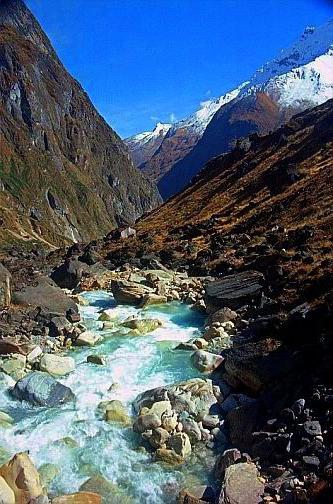
Rivers and lakes. Despite its great altitude, the Himalayas are not a watershed of river basins Indian Ocean and drainage region of Central Asia. Due to the presence of through antecedent gorges, the sources of the Indus, Sutlej, Karnali, and Arun rivers are located in the Karakoram and on the Tibetan Plateau. The largest rivers of South Asia - the Ganges and Brahmaputra - originate on the slopes of the Himalayas. The river network is more developed on the southern slope. In the upper reaches of the river they are fed by snow and glaciers; in the middle and lower areas it is rainy, with maximum water flow in summer. The valleys are narrow and deep. The rivers have enormous hydropower resources that are practically not used. Large hydroelectric power stations and reservoirs have been created on the Sutlej and Beas rivers. Lakes (of tectonic origin and glacial) are located mainly in the western part of the Himalayas below 5000 m (Wular, Tso-Morari, etc.); large alpine lakes - Bangong, Mapam-Yumtso. When glacial lakes break out, glacial mudflows can occur.

Soils, flora and fauna. The landscapes of the Himalayas are very diverse, especially on the southern slopes. The maximum number of altitudinal zones is typical for the most humid slopes of the eastern part of the Himalayas. The foot of the mountains is bordered by a strip of terai - swampy trees and shrubs (jungles) on meadow-swamp tropical soils. Moist evergreens grow higher up the slope rainforests on mountain red soils. The predominant species are dipterocarp, palm, pandanus, and tree ferns intertwined with lianas (up to 400 species). At an altitude of 1200-1500 m, mountain evergreen subtropical forests of oaks, laurel, magnolia, and tea trees (castanopsis, phoebe) dominate. Above 2000-2200 m they give way to mixed deciduous forests on brown forest soils, in the forest stand of which species of temperate latitudes appear - maples, alder, hazel, birch and conifers (Himalayan pine, Himalayan spruce, dense fir). At an altitude of 3000 m, the belt of mountain coniferous forests of pine, fir, hemlock, yew, and juniper begins. At an altitude of 3700-3900 m, it gives way to a subalpine belt - a crooked forest of huge rhododendrons and junipers with the participation of ferns; above 4000 m - a belt of alpine meadows, the upper border of which passes at an altitude of about 5000 m, individual plants (arenaria, edelweiss) rise to an altitude of 6100 m. In the central part of the Himalayas, in the spectrum of altitudinal zones, there is no belt of moist evergreen tropical forests, and up to an altitude of 600-1000 m, deciduous forests of tallow with the participation of terminalia, albizia, etc. dominate.
In the drier western part of the Himalayas, the lower parts of the slopes (up to 600 m) are occupied by sparse xerophytic forests and shrubs with wild olive, an admixture of acacias, pomegranate, and oleander on mountain brown soils. Higher up (up to 1200-1500 m) monsoon deciduous forests grow with the dominance of tall on mountain red soils, which are replaced by mountain subtropical mixed forests of holm oak and mountain pines with evergreen undergrowth. From an altitude of 2000-2500 m, mountain mixed subboreal forests of long-leaved pine (chir), fir, Himalayan cedar (deodar) with the participation of oaks, maples on low-humus brown forest soils dominate. The belt of 3000-3500 m is dominated by mountain coniferous forests of fir with an admixture of birch on podzolized brown soils. Above 3500 m there is a subalpine birch forest, thickets of juniper and rhododendrons, giving way to a belt of alpine meadows and shrubs on mountain meadow soils. The upper limit of distribution of vascular plants is 6300 m. The northern slope is characterized by desert-steppe landscapes with cushion plants and xerophytic grasses on thin rocky mountain-desert soils. Woody vegetation (willows, poplars) is found along river valleys.
The Himalayas are home to about 300 species of mammals, more than 10 of them are endemic (golden langur, Himalayan tahr, pygmy pig, etc.), 175 species of reptiles (about 50 species are endemic), 105 species of amphibians. The avifauna numbers about 1000 species (15 species are endemic). The fauna of the Terai and low-mountain Himalayas belongs to the Indo-Malayan faunal region. Large mammals live here - elephants, rhinoceroses, gaurs, wild boars, several species of deer (muntjac, sambar), among predators - tigers and leopards, red wolf; of birds - peacocks, pheasants, parrots. In the eastern part of the Himalayas, the binturong (the civet family) is found. The fauna of the middle and high mountains belongs to the Chinese-Himalayan subregion of the Holarctic region. The forest and alpine zones are inhabited by wild yak, musk deer, red deer (hangul), mountain sheep (argali, blue sheep), marking goat, goral, takin, and black Himalayan bear. The clouded leopard and snow leopard (irbis) are endangered. The most common birds are the Himalayan snowcock, Himalayan crested pheasant, and tragopans.
The most famous protected areas of the Himalayas are National parks Corbett, Greater Himalayas, Namdapha, Kanchenjunga (India); to the list World Heritage included the Manas Nature Reserve, Nandadevi and Valley of Flowers national parks (India), Kathmandu Valley, Chitwan and Sagarmatha national parks (Nepal). Mountaineering is widely developed in the Himalayas, mainly in Nepal. Climatic resorts - Shimla, Macypi, Darjeeling, etc. (India).
The main occupation of the population is Agriculture. On the northern slope of the Greater Himalayas (the vicinity of Lake Tangra-Yumtso) are the upper limits of agriculture in the world. Excessive grazing of livestock in alpine meadows and forests has led to increased erosion and mudflow processes.
Lit.: Singh G. Geography of India. M., 1980; Senkovskaya N. F. Land resources of the Himalayas and problems of their use // Bulletin of Moscow State University. Ser. 5. Geography. 1982. No. 6; she is the same. Features of the distribution of mudflow phenomena in the Himalayas // Ibid. 1984. No. 6; Kononov Yu. V. Country of subtropics and snow-capped mountains. M., 1985; Bedi R. Animal world India. M., 1987; Dolgushin L. D., Osinova G. B. Glaciers. M., 1989; Golubchikov Yu. N. Geography of mountain and polar countries. M., 1996; State of Nepal's environment. Kathmandu, 2000; Khain V. E. Tectonics of continents and oceans (year 2000). M., 2001; Inventory of glaciers, glacial lakes and glacial lake outburst floods monitoring and early warning systems in Hindu Kush - Himalayan region. Kathmandu, 2002.
N. N. Alekseeva; Arc. V. Tevelev ( geological structure and minerals).
The Himalayas are the highest mountain system on earth. About a third of all animal species living here - more than in other areas of India - belong to protected areas.
Basic data:
The Himalayan mountain system is one of the natural landscapes that are destroyed more quickly. Due to economic activity Humans are rapidly reducing the area of virgin corners of nature. Vacant lands are being developed, polluted and destroyed. Certain measures were taken to preserve this extremely valuable region, but obviously this was done too late. The cautious snow leopard (irbis), covered with beautiful thick yellow-gray spotted fur, light on the sides and white on the belly, became the object of hunting by hunters - sportsmen, poachers and fur traders.
Musk deer in the past lived everywhere in Himalayan mountains Oh. Musk, the secretion of the musk glands of male deer, has long been used in the perfume industry. As a result of active extermination, through human pursuit of profit, this animal found itself on the verge of extinction. In order to protect the musk deer, several reserves were organized, in particular, Kedernath and national park Sagarmatha.  Threatened species found in the Himalayas also include the brown bear, the white-breasted or Himalayan bear, the red panda and the black-necked crane (Grus nigricollis). Black-necked cranes were discovered by zoologist and traveler N. M. Przhevalsky. The Marco Polo sheep is a subspecies of argali, one of the largest Himalayan sheep.
People practice ecological agriculture.
The Chinese, earlier than others, began to use musk - the secretion of the musk deer's musk gland - in the production of fragrances.
The Himalayas are the natural border between Tibetan plateau Yam and India, Bhutan and Nepal, connecting in the northwest with the Hindu Kush ranges.
Do you know that…
96 of the 109 peaks higher than 7315 m belong to the Himalaya and Karakoram mountain systems.
Mount Qomolungma (Everest), whose height is 8848 m, is named after the English general George Everest (1790-1866), a geodesist and explorer of the topography of India.
The length of the horns of the horned goat, or markhor, living in the Himalayas (Capra falconeri) reaches 1.65 m.
Extent of the Himalayas
is about 2500 km, the width in some places reaches 400 km. The Himalayan mountains are predominantly located in Nepal and Bhutan, between the Tibetan Plateau and the Indo-Gangetic Plain. This mountain system is elongated and crosses several climatic zones, has a rich fauna and flora.
Insects
The jungles in the foothills of the Himalayas provide a favorable environment for many different insects. In higher areas, most insects have a dark body color, which allows them to accumulate solar heat during the day. Butterflies are amazing for their ability to live at high altitudes, flying at an altitude of 4500 m above sea level.
Relief formation
formed about 70 million years ago as a result of the collision of the Indian and Eurasian crustal platforms with subsequent deformation and uplift. The rich Himalayan flora and fauna includes South Asian, African and Mediterranean species.
In the east of the Himalayas, species native to Western China can still be observed today, and European Mediterranean species are found in the western part. Fossils indicate that typical African animals once lived here.
Vegetation
The Himalayas are divided into four vegetation zones: tropical, subtropical, temperate and alpine. All of them are located on different heights and are characterized by different amounts of precipitation. The Siwalik Mountains (Pre-Himalaya) are covered with tropical forests consisting mainly of bamboo, oaks and chestnuts. To the west, with increasing altitude, the forests thin out, and evergreen oaks, cedars and pines begin to dominate here.
At an altitude of 3700 m, the belt of alpine vegetation begins with its inherent rhododendrons and junipers.
Mammals
The uniqueness of the fauna of Tibet lies in the small number of species and the abundance of individuals, mainly ungulates - wild yaks, antelopes, mountain sheep. In cold, long winter conditions, many animals - foxes, martens, weasels, hares, marmots, pikas - dig deep holes. Typical inhabitants of the Himalayas are various types of mountain sheep. There are more of them here than in any other mountains in the world. A subspecies of mountain sheep lives here - the Marco Polo sheep. Hunters, harvesting its beautiful spiral horns, destroyed them almost completely. Another subspecies of argali lives here - the Tibetan argali, which can withstand extreme temperature fluctuations: both heat and winter cold. The following representatives of the bovid family also live in the Himalayas: the bearded goat, the mark-horned goat and the blue ram, the Himalayan goral, the tahr and the Takin, which is depicted on the coat of arms of the Kingdom of Bhutan. The Himalayan tahr lives on rocky slopes in forested strands of mountains; females rise above the forest line in summer. Kak is the largest mammal in this region. Thanks to its long, felt-like fur, it survives in the highest and most inhospitable mountainous areas. Animals domesticated by mountaineers are reliable and hardy companions for humans. Brown and Himalayan bears feed on carrion and are very fond of sweet fruits and roots. Perhaps the legend of Bigfoot, the Yeti, was inspired by the paw prints of the Himalayan bear.
The snow leopard, covered with thick fur, is not afraid of frost. The Himalayan bear is a shy animal.
Birds
The Himalayan feathered fauna includes Asian, European and Indo-Chinese species. Local forests are inhabited by numerous woodpeckers. In the mountains, birds live even above the forest limit - among them the Himalayan snowcock.
Himalayas
- real paradise for birds of prey. Himalayan or snowy vultures, bearded vultures and golden eagles, soaring high in the sky, look out for small animals and birds on the ground. The golden eagle occasionally attacks lambs and musk deer calves. Many local birds are characterized by bright, multi-colored colors. In the pheasant family, the Himalayan pheasants are the most distinguished by their plumage. The Himalayan pheasant lives in the eastern part of the Himalayas.
Himalayan vultures feed on the carcasses of deer and other large mammals.
The Himalayas are a world whose name, translated from Sanskrit, literally means “the place where snow lives.” Located in South Asia, this mountain range divides the Indo-Gangetic Plain and is home to most of the closest points to the sky on planet Earth, including Everest, the highest point (the Himalayas are not called the “roof of the world” for nothing). It is also known under another name - Chomolungma.
Mountain ecology
The Himalayan mountains have a wide variety of landscape shapes. The Himalayas lie on the territory of five countries: India, Nepal, Bhutan, China and Pakistan. Three large and powerful rivers- Indus, Ganges and Brahmaputra. The flora and fauna of the Himalayas is directly dependent on climate, rainfall, mountain height and soil conditions.

The area around the base of the mountains is characterized by a tropical climate, while the tops are covered with perpetual ice and snow. Annual precipitation increases from west to east. Unique natural heritage and the height of the Himalayan mountains are subject to modification due to various climatic processes.

Geological features
The Himalayas are mountains consisting predominantly of sedimentary and mixed rocks. Distinctive feature mountain slopes are their steepness and peaks in the form of a peak or ridge, covered eternal ice and snow and occupy an area of about 33 thousand km². The Himalayas, whose height in some places reaches almost nine kilometers, are relatively young compared to other, more ancient mountain systems on Earth.

As it did 70 million years ago, the Indian plate is still moving and moving up to 67 millimeters per year, and over the next 10 million years it will move 1.5 km in an Asian direction. What also makes the peaks active from a geological point of view is that the height of the Himalayan mountains is increasing, gradually rising by approximately 5 mm per year. Such seemingly insignificant processes over time have a powerful influence in geological terms; in addition, the area is unstable from a seismic point of view, and earthquakes sometimes occur.

Himalayan river system
The Himalayas have the third largest deposits of ice and snow in the world after Antarctica and the Arctic. There are approximately 15 thousand glaciers in the mountains, which contain about 12 thousand cubic kilometers of fresh water. The highest areas are covered with snow all year round. The Indus, which has its origins in Tibet, is the largest and deepest river, into which many smaller ones flow. It flows into southwest direction through India, Pakistan and flows into the Arabian Sea.

The Himalayas, whose height reaches almost 9 kilometers at its highest point, are characterized by great river diversity. The main water sources of the Ganges-Brahmaputra basin are the Ganges, Brahmaputra and Yamuna rivers. The Brahmaputra joins the Ganges in Bangladesh and together they flow into the Bay of Bengal.

Mountain lakes
The highest Himalayan lake, Gurudongmar in Sikkim (India), is at an altitude of about 5 kilometers. In the vicinity of the Himalayas there is great amount picturesque lakes, most of which are located at an altitude of less than 5 kilometers above sea level. Some lakes are considered sacred in India. Nepal's Lake Tilicho, in the vicinity of the Annapurna mountain landscape, is one of the highest on the planet.

The great Himalayan mountain ranges contain hundreds of beautiful lakes in India and neighboring Tibet and Nepal. The Himalayan lakes add special appeal to the magnificent mountain landscapes, many of which are steeped in ancient legends and interesting stories.

Impact on climate
The Himalayas provide big influence on climate formation. They prevent the flow of cold, dry winds in a southerly direction, which allows a warm climate to reign in South Asia. A natural barrier is formed for the monsoons (causing heavy rainfall), preventing their movement in a northerly direction. The mountain range plays a certain role in the formation of the Taklamakan and Gobi deserts.
The main part of the Himalayan mountains is influenced by subequatorial factors. In the summer and spring season it is quite hot here: the average air temperature reaches 35 °C. At this time of year, the monsoons bring with them large amounts of precipitation from the Indian Ocean, which then falls on the southern mountain slopes.

People and culture of the Himalayas
Because of climatic features The Himalayas (mountains in Asia) are a fairly sparsely populated region. Most people live in the lowlands. Some of them earn their living as guides for tourists and escorts for climbers who come to conquer some Mountain peaks. The mountains have been a natural barrier for many thousands of years. They stopped the assimilation of the interior of Asia with the Indian peoples.
Some tribes are based in mountain range The Himalayas, namely in North-East India, Sikkim, Nepal, Bhutan, parts of West Bengal and others. Arunachal Pradesh itself is home to more than 80 tribes. The Himalayan mountains are one of the largest places at peace with big amount endangered species of animals, since hunting is very popular view activities in the vicinity of the Himalayas. The main religions are Buddhism, Islam and Hinduism. A famous Himalayan myth is the story of Bigfoot, who lives somewhere in the mountains.

Height of the Himalayan mountains
The Himalayas rise almost 9 kilometers above sea level. They extend over a distance of about 2.4 thousand kilometers from the Indus Valley in the west to the Brahmaputra Valley in the east. Some mountain peaks are considered sacred among the local population, and many Hindus and Buddhists make pilgrimages to these places.
On average, the height of the Himalayan mountains in meters together with glaciers reaches 3.2 thousand. Mountain climbing, which has gained popularity in late XIX century, has become the main activity of extreme tourists. In 1953, New Zealander and Sherpa Tenzing Norgay were the first to conquer Everest (the highest point).

Everest: mountain height (Himalayas)
Everest, also known as Chomolungma, is highest point planets. What is the height of the mountain? Known for its inaccessible peaks, the Himalayas attract thousands of travelers, but their main destination is the 8,848-kilometer-high Qomolangma. This place is simply a paradise for tourists who cannot imagine their life without risk and extreme sports.
The height of the Himalayan mountains attracts a large number of climbers from all over the globe. As a rule, there are no significant technical difficulties with climbing certain routes, but Everest is fraught with many other dangerous factors, such as fear of heights, sudden changes weather conditions, lack of oxygen and very strong gusty winds.

Scientists have accurately determined the height of every mountain system on Earth. This was made possible through the use of NASA's satellite observation system. Having measured the height of each mountain, we came to the conclusion that 10 of the 14 highest on the planet are in the Himalayas. Each of these mountains belongs to a special list of “eight-thousanders”. Conquering all these peaks is considered the peak of a mountaineer's skill.

Natural features of the Himalayas at different levels
The Himalayan swampy jungles located at the foot of the mountains are called "Terai" and are characterized by a wide variety of vegetation. Here you can find 5-meter thickets of grass, palm trees with coconuts, ferns and bamboo thickets. At an altitude of 400 meters to 1.5 kilometers there is a strip of rainforest. In addition to numerous species of trees, magnolias, citrus fruits and camphor laurel grow here.

At a higher level (up to 2.5 km), the mountain space is filled with evergreen subtropical and deciduous forests; here you can find mimosa, maple, bird cherry, chestnut, oak, wild cherry, and alpine mosses. Coniferous forests extend up to a height of 4 km. At this height, there are fewer and fewer trees, they are replaced by field vegetation in the form of grass and shrubs.

Starting 4.5 km above sea level, the Himalayas are a zone of eternal glaciers and snow cover. The fauna is also diverse. In different parts of the mountainous surroundings you can encounter bears, elephants, antelopes, rhinoceroses, monkeys, goats and many other mammals. There are many snakes and reptiles here, which pose a great danger to people.
The Himalayas are the highest mountain system on Earth. To date, the peak of Chomolungma (Everest) has been conquered about 1200 times. Among them, a 60-year-old man and a thirteen-year-old teenager managed to climb to the very peak, and in 1998 the first person with disabilities reached the peak.
The most majestic and mysterious mountain range on our planet is the Himalayas. This massif, whose name translates as the abode of snow, conventionally separates the Central and South Asia, And the height of its individual peaks reaches more than 8,000 meters. The Himalayas are rightfully considered the most high mountains in the world, look at the Himalayas on the map and find out why these mountains are so unusual.
Location of the Himalayas mountain system on the world map
“Where are the Himalayas, in which country?” - this question often arises among novice travelers who have heard about the beauty of the most inaccessible mountains planet and decided to go there in search of adventure. Looking at the world map, you can see that the Himalayas are located in the northern hemisphere between the Tibetan Plateau and the Indo-Gangetic Plain. India, Nepal, China, Pakistan, Bhutan and Bangladesh are the countries whose territories cover the Himalayas. The most visited country in the Himalayas is India. There are many attractions and resorts here. The massif is 2900 km long and about 350 km wide. IN mountain system There are 83 peaks, the highest of which is Everest, the height of the mountain is 8848 m.
The Himalayan mountains on the map consist of three main stages:
- Siwalik Range. This is the most South part mountain range. The ridge is located in Nepal and affects several states of India. Here the height of the Himalayan mountains does not exceed 2 km.
- Small Himalayas. This ridge runs parallel to the Siwalik Range. The average altitude here is 2.5 km.
- Great Himalayas. This is the highest and ancient part mountain range. The height of the ridge exceeds 8 km, and it is here that the most high peaks planets.
Highest Peaks
The mountain range contains 9 of the 10 highest peaks in the world. Here are the highest ones:
- Chomolungma – 8848 m.
- Kanchenjunga – 8586 m.
- Lhotse – 8516 m.
- Makalu – 8463 m.
- Cho Oyu – 8201 m.
Most of them are located on the territory of Tibet, and this is where mountain conquerors from all over the planet flock, because climbing the highest peaks is the life’s work of a real climber.
Flora and fauna
 The flora of the Himalayas changes with changes in altitude. Natural features The Himalayas at different levels surprise with the change of landscapes, animals and flora. In the foothills of the small Himalayas, terai or swampy jungles predominate, above them they are replaced by tropical forests, then mixed, coniferous, and finally, alpine meadows appear. Deserts and semi-deserts predominate on the northern slopes. The fauna of the Himalayas is as diverse as the flora. Here you can still find wild tigers, rhinoceroses, elephants and monkeys, and when you rise higher, the risk of encountering a bear, mountain yak and snow leopard increases.
In the mountains that captivate Nepal, there is a unique nature reserve, where endangered species of animals still exist. The zone is under the protection of UNESCO. Mount Everest is located within this reserve.
Rivers and lakes
It is in the Himalayas that the three most large rivers South Asia. These include the Ganges, Brahmaputra and Indus. Moreover, in the mountain range there are many beautiful and cleanest lakes. The highest mountain is Lake Tilicho, located at an altitude of 4919 m.
The special pride of the Himalayas is, of course, the glaciers. By the amount of fresh water reserves mountain range only the Arctic and Antarctic were bypassed. The largest glacier here is the Gantotri formation, which reaches a length of 26 km.
When is it nice to be in the Himalayas?
According to travelers, it is always good in the Himalayas. Each season gives the slopes of this ridge unique landscapes, the beauty of which is simply impossible to describe in words. In spring, the slopes are strewn with beautiful flowers, the aroma of which spreads for many kilometers; in summer, during the rainy season, lush greenery breaks through the light fog and gives freshness and coolness; autumn is a riot of colors; and in winter, when snow falls, there is no cleaner and whiter place in the world.
Basic tourist season falls in the autumn months, but even in winter there are many skiing enthusiasts here, because in the Himalayas there are many ski resorts of global significance.
It might be useful to read:
- How to get on an excursion to Antarctica?;
- Czech Republic Troy Castle. Troja Castle in Prague. Ancient winery and museum;
- Böcklin and his “island of the dead” A cultural phenomenon of its time;
- Air tickets to Crimea Air tickets to Crimea will become cheaper;
- What you can and cannot take with you;
- Open left menu Heviz How to get from Budapest to Lake Heviz;
- Cable car in Nha Trang (Vinpearl) The longest cable car in the world Vietnam;
- Kamenets-Podolsk fortress - a historical monument of Ukraine Life outside the walls of the Kamenets-Podolsk fortress;